Michael Engle
Staff Writer
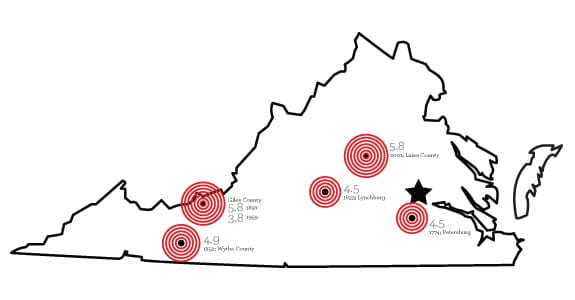
VCU’s student convocation featuring author Wes Moore was postponed Tuesday, Aug. 23 due to an earthquake centered in Mineral, Va. in Louisa County. The quake was a magnitude 5.8.
The epicenter of the earthquake was about 40 miles northwest of Richmond and initially was measured as a magnitude 5.9. Since then, the U.S. Geological Survey has ruled the quake was actually a 5.8.
The last major earthquake in Virginia was a magnitude 4.5 and was reported to be about 30 miles away from Richmond. The last earthquake that measured close to Tuesday’s 5.8 was in Giles County in 1897, where a magnitude 5.9 earthquake was recorded.
In the wake of the earthquake, VCU Facilities Management has not yet found any substantial damage around the Monroe Park or MCV campuses.
There were no major injuries reported in Richmond, though three residents of the elderly living community Fay Towers were hospitalized for pre-existing medical conditions. Others were examined at the scene after the building was evacuated. Residents were allowed to return to their building Tuesday night.
Louisa County, however, has shut down its six area schools through Labor Day while continuing to assess the damage caused by the quake. Six students and one staff member at Louisa County High School were injured. Only one was hospitalized.
The Virginia Department of Transportation inspected bridges in Richmond, Fredericksburg and the Culpepper regions. They also inspected four highway tunnels in Hampton Roads and two mountain tunnels on Interstate 77 in southwest Virginia. No damage has been found.
The quake was felt up and down the East coast and prompted the federal government to send workers home and evacuate the Pentagon building Tuesday afternoon. By Tuesday evening, major news circuits were reporting a crack in the top of the Washington Monument. The monument is now closed indefinitely.
While most citizens were safe with little property damage, Dominion Power was concerned with its North Anna nuclear power plant near Mineral. The plant lost power because of the quake, but both nuclear units were shut down safely.
Aftershocks ranging from a 2.2 to a 4.2 on the Richter scale continued to be centered around Louisa but were felt through Richmond. By Wednesday morning, four aftershocks had been recorded.
According to the U.S. Geological Survey, aftershocks can continue for days after the initial quake, but there is no real way to predict how long they could last.
VCU’s student convocation has not yet been rescheduled.


Leave a Reply